Rivers in Sundarban – The Liquid Highways of a Living Forest
Last Updated: February 17, 2026
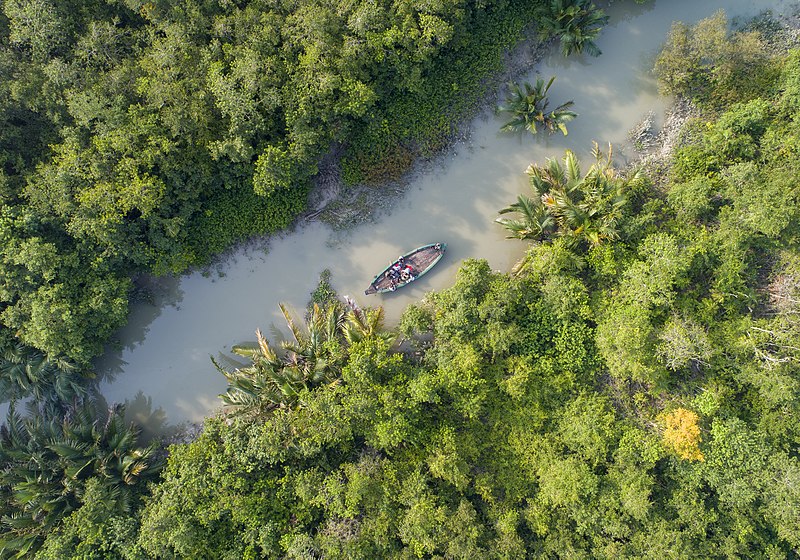
The Sundarban is a landscape where land and water continually reshape one another. Here, rivers are not mere geographical lines on a map—these waterways are the region’s living infrastructure. They carry tides, sediment, nutrients, people, and wildlife through one of the world’s most complex mangrove ecosystems.
When you begin a Sundarban Tour, your safari is fundamentally river-based. The boat becomes your viewpoint, the river your trail, and the tide your timetable. For travelers seeking quieter routes and flexible creek exploration, a Sundarban private tour
often provides better control over timing and navigation.
A Delta Born of Giants – Ganges, Brahmaputra, and Meghna
The Sundarbans exist because of a vast delta-building system formed by the confluence of three major rivers:
the Ganges, the Brahmaputra, and the Meghna.
Their combined flows create the Ganges–Brahmaputra–Meghna delta—one of the largest and most dynamic delta systems on Earth.
Ganges (Approx. 2,510 km)
The Ganges brings freshwater pulses, nutrient-rich sediment, and seasonal flow variation that influence delta fertility.
In the Sundarban context, these inputs help sustain mangrove productivity and fisheries—especially in zones where freshwater influence remains stronger.
Brahmaputra (Approx. 2,900 km)
The Brahmaputra system carries a massive sediment load, shaping islands, channels, and embankments across the delta.
Over time, this sediment movement is one of the reasons the Sundarban river network constantly evolves.
Meghna (Lower course approx. 264 km)
The Meghna, acting as a powerful estuarine outlet, delivers combined river discharge toward the Bay of Bengal.
Its tidal energy and estuary dynamics influence salinity patterns and coastal processes across the wider delta.
Gosaba – The Gateway Island for River Safari Routes
Gosaba is often considered one of the most important inhabited islands in the Sundarban region and a practical “gateway” for many travel routes. It is a key transit zone where local markets, supplies, and river connections support tourism movement into the mangrove interior.
Most visitors begin their itinerary through a structured Sundarban Tour Package, while travelers who prefer privacy, timing flexibility, and exclusive cruising typically select a Sundarban private tour.
Tides That Rule the Land
Sundarban rivers experience a strong tidal rhythm twice daily. High tides flood creeks and channels, while low tides reveal mudflats and exposed mangrove roots.
This daily cycle shapes every movement in the region—from boat routing to bird activity.
It determines navigation windows for narrow creeks.
It influences feeding activity along mudflats (especially for wading birds).
It reshapes banks, islands, and sandbars across seasons.
Beyond the headline rivers, the Sundarbans are defined by distributaries, tidal channels, and estuarine corridors.
These smaller rivers form the true “navigation grid” of the mangrove forest and support fisheries, village transport, and wildlife habitat.
Matla River – The Salty Sentinel
Nature: Tidal estuarine river with strong saline influence
Role: Major navigation corridor for tourism boats and local transport
The Matla is widely known for strong tides and higher salinity. For many travelers, it is the first dramatic river vista—
wide water, distant mangrove lines, and a sense of scale that immediately defines “delta travel.”
Bidyadhari River – The Forgotten Artery
Nature: Historic channel with altered freshwater connection over time
The Bidyadhari’s changing flow reflects larger shifts in delta hydrology.
Its quieter stretches are often appreciated by travelers seeking low-noise cruising and a more secluded waterway feel.
Hogla River – The Hidden Passage
Nature: Tidal distributary within the Sundarban network
Best for: Birdwatching routes, calm creek-like travel sections
The Hogla is less traveled and therefore valuable for offbeat routing and birding-focused exploration. If your priority is private timing and exclusive creek navigation, consider planning through a Sundarban private tour.
Life Along the Rivers
For People
Fishing: Hilsa, prawns, and crabs sustain livelihoods and local markets.
Transport: Boats move people, supplies, and essential goods across islands.
Trade: River routes connect jetties, markets, and village clusters.
For Wildlife
Habitat zones: Freshwater–brackish gradients support diverse species niches.
Movement corridors: Tidal channels support seasonal shifts in aquatic life.
Cultural Landmarks Along Sundarban Rivers
A river safari is also a cultural journey. Riverside villages, small shrines, and folk narratives reflect how communities have adapted to living beside a protected forest. To understand the human dimension better, you may also read: Sundarban Culture & Heritage.
Night Magic – Bioluminescence and Water Glow
Under the right conditions (dark sky, minimal light pollution, and suitable water ecology), some travelers report seeing faint spark-like glows in disturbed water. Availability depends on season, location, and natural conditions—so it should be treated as a rare bonus rather than a guaranteed sighting.
Why Sundarban Rivers Make This Safari Unique
Most wildlife regions are explored by jeep or trail. In the Sundarbans, your primary exploration is on water. Rivers allow you to observe mangrove edges, mudflats, creeks, and bird habitats with minimal disturbance. This is precisely why a river-first itinerary is central to any Sundarban tour package.
Tips for a River-Centric Sundarban Trip
Plan with tides: High tide helps enter narrow creeks; low tide improves mudflat bird visibility.
Choose the right itinerary: For flexible cruising and quiet routes, select a Sundarban private tour.
Pack for river conditions: Light clothing, sun protection, mosquito repellent, and waterproof storage.
Stay eco-responsible: No littering, no loud music, and respect local community privacy.